Giggity giggity!
That post seems to be missing.
EldritchFeminity 3 points 3 years ago
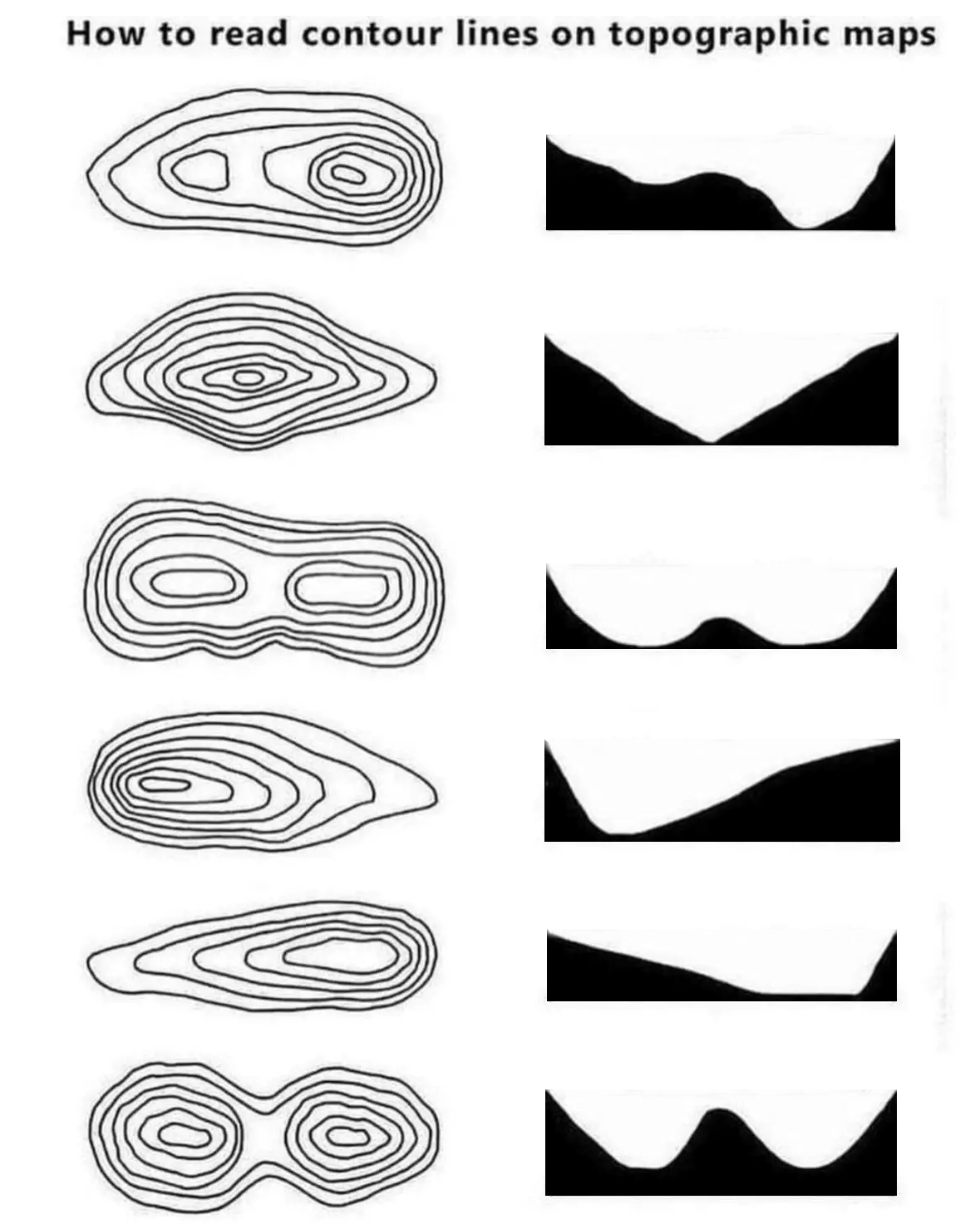
It gives a basic idea, but I think something like Cities:Skylines where you can create maps using a height map and then get the topography lines in a 3d space where you can actively shift the camera around to see them overlaid from any angle would probably help people grasp the idea.
Having said that, I'm now imagining drone footage overlaid with the height maps as an additional resource to standard topographical maps. Would be neat if somebody could create software that could calculate and overlay the height maps in real-time using the drone's altimeter or something.
DAMunzy 5 points 3 years ago
In the Land Nav portion of PLDC (US Army training for becoming a Sergeant - is called something else now) there were soooooo many people that failed out/had to do it over again, that I was super worried when I did it. Seemed pretty damn easy to me. 🤷
misterdoctor 31 points 3 years ago
You want an example of local depression just swing by my place anytime
HerbalGamer 6 points 3 years ago
heyoooo!
IlliteratiDomine 18 points 3 years ago
Here's a slide describing how depressions are represented, and here is a topographical map of a sinkhole showing the hashes.
That said, I had to look pretty hard for a map with those marks. Numbers are much more common.
BCsven 6 points 3 years ago
Ah, awesome. i appreciate you taking the time to put this together. I dont recall these on maps, but as you said numbers are common. And i typically use the topomap with shading, so shading helps with understanding the terrain
Jessica 3 points 3 years ago
Page 2 under contours: https://pubs.usgs.gov/...
meyotch 1 point 3 years ago
A Wisconsin DNR pdf explaining how to identify local depressions on a topo map
They are an oddity for sure. But sometimes there’s a local divot that would be interpreted as a small mound without the hatch marks.
samus12345 6 points 3 years ago
Yeah, very confusing to see an image like this that isn't a smart-ass meme.
RatsOffToYa 5 points 3 years ago
Nature's boobs
Glimpythegoblin 22 points 3 years ago path: 0 5591853, hotness: undefined, score: 22, children: 1
HerbalGamer 4 points 3 years ago
Thank you for your service o7
ubermeisters 17 points 3 years ago path: 0 5583155, hotness: undefined, score: 17, children: 11



EuroNutellaMan 17 points 3 years ago
Number 3 is basically just my chair if it was soft like a sofa instead of wood
Potatos_are_not_friends 4 points 3 years ago
Have you seen those chairs with butt imprints?
Squirrel 16 points 3 years ago
There are depression contour lines for that purpose.
Pregnenolone 12 points 3 years ago
Depression contour lines are what I call my wrinkles
Rentlar 4 points 3 years ago
I think this is the first time on Lemmy, where in a single thread I had simultaneously learned something interesting and educational and had laughed so hard, it is a rare occurence.
Thank you and @squirrel@thelemmy.club for that.
funkless_eck 11 points 3 years ago
blows dust off old website
DarkMessiah 6 points 3 years ago
First time I’ve seen that, really don’t think it should’ve been my first time. Thanks!
ubermeisters 8 points 3 years ago path: 0 5583155 5583340 5584267, hotness: undefined, score: 8, children: 0
gullible 12 points 3 years ago
I’ve always been curious about topographical maps that involve curved or hanging terrain and whether there’s a way to denote the existence of an area beneath. That’s obviously going to be irrelevant 99.9% of the time, but grade school curiosity rarely fades completely.
finnspiration 10 points 3 years ago
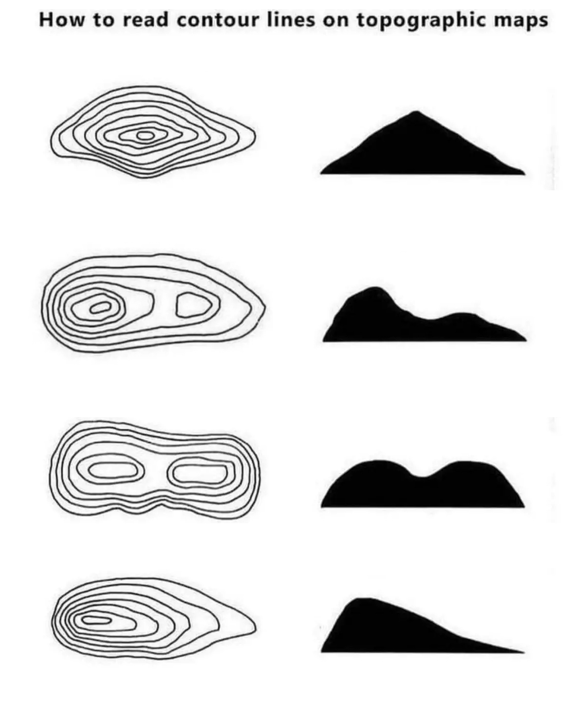
I made an improved condensed version of this that still gets the point across
Hikermick 6 points 3 years ago
Also it helps to look at water on the map. Water always runs downhill. Runs combine to form creeks, creeks combine to form rivers, rivers pour into oceans and lakes. Water gets bigger on its way downhill. The dead end is a spring, it flows downhill from there
AgentGrimstone 5 points 3 years ago
For the second one, do you need that many rings? Would using less still be correct?
nymwit 11 points 3 years ago
Depends on the rest of the map. These are usually set up so the rings mean a certain consistent difference in elevation, say 1ft of 10ft. You don't normally change the spacing partway through the map. If the intervals were 10ft and this was a 20ft peak then you'd obviously have fewer rings than if the intervals were 1ft.
OceanSoap 10 points 3 years ago
The rings are elevation placements. Less would be "correct in that they'd still signify elevations, it's just less detailed.
For example, the widest ring might be an elevation of 2470ft while the smallest ring might be 2570ft. If there are no rings in between, it's still correct, you're just not getting very detailed. You could easily be looking at a perfect sloap on all sides, like a smooth cone. But place 9 rings in between at 10ft more of elevation each, you've got a much more detailed idea of how a mountain or hill is shaped.
So, correct, but not very useful.
emptiestplace 2 points 3 years ago
Utility may be subjective, but sloap perfection is forever.
thanks for using Leebra!
go to feed...
Everything reminds me of her
save